10 Free GIS Data Sources Best Global Raster and Vector Datasets

Source: GIS Geography

10 Free GIS Data Sources

We live in the information age. We get blasted by truckloads of information each day. In terms of free GIS data sources, it seems never-ending.

So that’s why we’ve put together this list to turbo-charge your search for reputable and free GIS data.

In other words: these 10 free GIS data sets are the best of the best.

We can ensure that all are from authoritative sources. Let’s get started.

1. Esri Open Data Hub

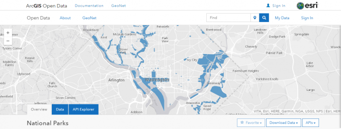
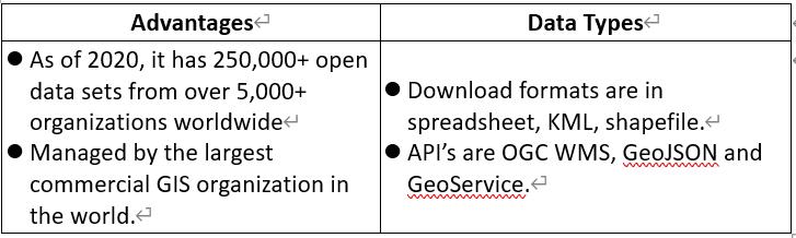
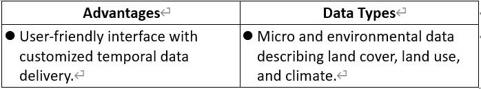
In 2020, the Esri Open Data Hub is a hidden gold mine of free GIS data. For example, it now houses over 250,000+ open data sets from 5,000+ organizations worldwide. For this reason, we have it at the top of our list of free GIS data.

In some cases, you’ll have to sift through piles of data because they’re not conveniently merged into one. Despite the extra effort, this is still arguably your best chance to find exactly what you’re looking for.

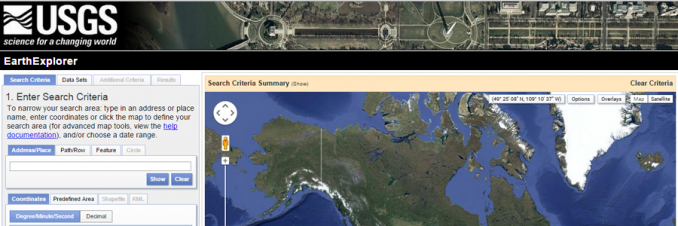
In any case, the search is convenient with a map preview of the extent and table. Alternatively, you can search by topic or location and download data in multiple GIS formats. Ultimately, there is nothing more thorough for GIS data than the Esri Open Data Hub.

2. Natural Earth Data

Natural Earth Data is number 2 on the list because it best suits the needs of cartographers. By and large, all the key cultural and physical vector GIS datasets are on a global scale conveniently for you to use. The raster datasets also provide beautiful hill shade relief for your map.

The best part is Natural Earth Data is in public domain. So this means that you have the right to use, modify, and disseminate the data in any manner.

Here’s more details for Natural Earth data. From a cartography standpoint, it’s a no-brainer. Download Natural Earth Data now.

3. USGS Earth Explorer

For satellite and aerial imagery, the USGS Earth Explorer is one of the largest free sources of data. The best part? You can download data outside of the United States too.

A friendly user-interface makes accessing remote sensing data simple. In fact, it even has a bulk download application if you need to download more than one data set.

Registration is free. If you’re looking for other satellite data providers, check our list of 15 free satellite imagery sources.

4. OpenStreetMap

GIS users are harnessing the power of OpenStreetMap (OSM) as a means to crowdsourced data. The result of crowd-sourcing is highly detailed data. But I say detailed with cautious optimism.

While OSM is open to the public, it’s also created by the public. So this means that accuracy varies based on the creator. From my experience, accuracy is very good. And people like you and me are working on completeness every day.

For GIS analysts seeking free GIS data at a street level, OSM is exactly what you are looking for. For example, it may be the biggest inventory of buildings in the world.

How much data is being created every second into OpenStreetMap? There’s a map for that – OSM Show Me The Way.

5. NASA’s Socioeconomic Data and Applications Center (SEDAC)

NASA’s Socioeconomic Data and Applications Center (SEDAC) shows human interactions with the environment. SEDAC has a wide variety of coarse global free GIS data.

For example, their flagship data product is a gridded population of the world. With 800+ citations, it includes population characteristics such as age, education, and density. And the global urban and local populations extents come from nighttime lights

I like the SEDAC map viewer because you can select GIS thematic maps of the socioeconomic data. If you want to assemble the data yourself, there’s that option too.

6. Open Topography

Open Topography provides a portal to high spatial resolution topographic data and tools. In particular, it houses LiDAR Data, which is a rare, precious resource nowadays.

Currently, Open Topography has collected 300 high resolution datasets. Most are point clouds. But some are just available in raster format. Their data map shows the most available data is in the United States. But data is also available in Europe, Asia, and Australia too.

If you can’t find LiDAR data for your area of interest, the next best thing is a global DEM. These free GIS data sets are also available on Open Topography too.

7. UNEP Environmental Data Explorer

United Nations Environment Programme (UNEP) is the authoritative source for UN data. For example, it holds more than 500 variables such as freshwater, climate and health.

I must admit. I found it a bit difficult to explore the GIS data because the interface takes a while to get used to. If you click advanced, you can filter “Geospatial Data Sets”. From here, you can download free GIS data like climate, disasters, and ecosystems.

8. NASA Earth Observations (NEO)

Imagine seeing daily snapshots of climate and environmental conditions of Earth. NASA’s Earth Observations (NEO) is like a real-time climate snapshot of the world.

NEO focuses on 5 themes with 50+ global datasets, mostly climate-related. For example, data ranges from aerosols, chlorophyll to sea surface temperature. All are free GIS data sets that you can download in JPEG, GeoTIFF, and Google Earth formats.

When it comes to understanding our climate, you can’t live without NASA’s NEO. If you can’t find what you’re looking for, we have a whole list of 7 free world climate data sources

Sentinel-2 is the highest resolution satellite imagery available to the public for free. Its interface is the Copernicus Open Access Hub.

First, you have to register to create an account. But it’s well worth the time. Next, select your area of interest by right-clicking on the map. Finally, select the S2A or S2B product you want to download and download.

The Copernicus Open Access Hub also stores Sentinel-1 which is synthetic aperture radar. So, be careful about what you choose to download.

READ MORE: How to Download Sentinel Satellite Data for Free.

10. Terra Populus

Terra Populus (TerraPop for short) integrates census data from over 160 countries around the world. In fact, it spans up to six decades for household-level and aggregate data for more than 80 countries.

The unique thing about it is how you can explore temporal and spatial changes. It’s not only for researches. But everyone can access changes in the human-environment system for geographic space.

TerraPop also includes your basic land cover, land use, and climate data. It’s supported by the National Science Foundation and the University of Minnesota. Even now, updates keep rolling out.

Bonus 1: FAO GeoNetwork

We’re going above and beyond our 10 free data sources here so this is a bit of a bonus. This one is the FAO GeoNetwork which is another portal of free GIS data from the United Nations.

The focus of GeoNetwork is to improve global sustainable development. For example, global agriculture, food security, and fisheries are some of its key free GIS data.

Bonus 2: ISCGM Global Map

Unfortunately, the International Steering Committee for Global Mapping (ISCGM) portal no longer exists. But that doesn’t mean the data is gone forever. That’s because ISCGM archived their data to the Global Map Github.

Global Map still packs some serious punch with its free GIS data. For example, global land cover and percent tree cover are the two key datasets here. But that’s not all. It has cultural and natural vector datasets here too.

Since the move, registration is no longer required. Despite the lack of updates, ISCGM free GIS data is still a source that many of us can use in our maps.

Download Free GIS Data

In a perfect world, you’d be able to find all the free GIS data you need on a single website. Of course, it would have to be free, downloadable from an authoritative source.

But well, you know the drill. The world’s not perfect, life’s not fair.

That’s why we put together this list of 10 global GIS data sets that you can download for free.

Using this list, you have instantly become more knowledgeable with these 10 free GIS data sources.

发表评论

邮箱地址不会被公开。 必填项已用*标注