15 Free Satellite Imagery Data Sources

Source: GIS Geography

Free Satellite Imagery from Authoritative Sources

The secret is there are dozens of authoritative sources with high-quality satellite imagery. But wait there’s more. Not only can you download the latest, greatest satellite imagery… but it’s all FREE.

All you need to know is where to find them. Read below to see our go-to list of free satellite imagery sources. And remember – if you just want to look at satellite imagery without downloading the data, check out our list of 25 satellite maps.

1. USGS Earth Explorer

Unlock the power of the USGS Earth Explorer because it’s not just for the United States. No matter where you live, the USGS Earth Explorer offers the latest satellite view like:

  • LANDSAT: Silently, Landsat has been circling our planet archiving historical satellite imagery. As early as today, it uploads it to the USGS Earth Explorer.
  • SPY SATELLITES: Imagine being able to look back more than 50+ years in the past. How much would that be worth? Spy satellite imagery like CORONA has been declassified over the years and completely available to the public.
  • HYPERSPECTRAL: If you don’t know what hyperspectral imagery is, it’s like having spectral detail on steroids. Hyperion was the experimental instrument imagined by NASA. Now, Earth Explorer is the only place where you can download this hyperspectral imagery.

USGS Earth Explorer is a world-class source for data. If you’re not familiar with how to use it, here’s a guide for how to download free Landsat imagery from the USGS Earth Explorer to help you get started.

2. Sentinel Open Access Hub

Sentinel-2 is the start of a new and exciting era in open and free satellite imagery. It’s not just because coverage spans the entire globe. But it’s also because Sentinel-2 has some of the most current satellite photos available to download at a high resolution.

Sentinels Open Access Hub is the official headquarters to download Sentinel imagery. It’s a bit quirky to get used to, so check out our guide for how to download Sentinel-2 imagery.

  • SENTINEL-2: Two satellites make Sentinel-2. Due to its popularity, there will be 2 more satellites in the coming years. Sentinel-2 has 10-meter resolution in red, green, blue and near-infrared. Its 12 spectral bands range from coastal to SWIR bands. It’s just been 5 years since its launch. But demand has soared, making it one of the most popular free satellite imagery available.
  • SENTINEL-1: If you need synthetic aperture radar (SAR) imagery, Sentinel-1 is C-band. The potential for SAR is endless. But you don’t get the pretty picture like Sentinel-2.

After you download Sentinel imagery, how do you use it? Download the ESA’s open source Sentinel-2 Toolbox. All toolboxes give you the framework to embrace a rich set of analysis, visualization, and processing tools.

3. NASA Earthdata Search

There’s a lot to like about NASA’s Earthdata Search, specifically for Earth science data discovery. Especially, the choices of satellite imagery are incredible.

  • DERIVED DATA: Most of NASA’s Earth Data is an analysis product for the study of Earth Science. For example, it’s anything from the biosphere, cryosphere, hydrosphere or atmosphere. Most products come from a data and applications center (DAAC).
  • LAND COVER: NASA Earthdata is also an excellent source of global land use and cover. But it’s not just your typical land cover classes. It has specialized satellite-derived data like permafrost and wetland types.

Our suggestion is to start with a simple search. Then, change the time range criteria to narrow down your search. Finally, download your free satellite imagery. You’ll get the hang of it after a couple of tries. This NASA’s EarthData Search Usage Tutorial will help.

4. NOAA Data Access Viewer

NOAA replaced their aerial photography ordering system with the NOAA Data Access Viewer. Now, it’s where you discover authoritative datasets along the coasts. But it’s not only for satellite imagery. You can download:

  • AERIAL/SATELLITE IMAGERY: The NOAA Data Access Viewer holds satellite, aerial and LiDAR imagery. First, enter in your area of interest. Once you do this, all the available data sets will appear in the right-side pane. From here, all you have to do is download.

NOAA Data Access Viewer is out of beta mode now. But the download speeds are still slow and sluggish. Overall, this is a great option for coastal areas like California, Florida, and New York.

5. DigitalGlobe Open Data Program

If you want high-resolution satellite imagery in the world, try harnessing the power of DigitalGlobe. In fact, it’s so sharp that you can almost see license plates.

By no means, you can download the entire DigitalGlobe library of 30cm imagery for free. Instead, you can download free satellite imagery from DigitalGlobe in two ways:

  • OPEN DATA PROGRAM: For any natural disaster, DigitalGlobe’s Open Data Program supplies satellite imagery for relief. For example, fires, floods, hurricanes, typhoons and earthquakes are part of this list. They release data into the public domain under a Creative Commons 4.0 license. Take a look for any recent natural disaster event, and I’ll bet you it’s there.
  • SAMPLE DATA: If you want to simply experiment, try downloading from their sample imagery. For example, it has building footprints, elevation, stereo and true color imagery.

These are examples of high-resolution satellite imagery. If you couldn’t find what you were looking for here, the next option is your second best choice.

6. Geo-Airbus Defense

Just like DigitalGlobe, Geo-Airbus Defense is a commercial vendor. From satellites like SPOT, Pleiades, RapidEye, these are some of the best in class.

Geo-Airbus Defense also has a collection of sample imagery. But unfortunately, their free satellite imagery selection is quite limited.

  • SAMPLE IMAGERY: Geo Airbus Defense Systems offers 140+ sample images for experimentation. For optical imagery, it gets as finer as 1.5 meters with SPOT. Radar imagery from TerraSAR-X is as sharp as 3 meters. Finally, you can get a cut of the unrivaled 12-meter WorldDEM. This is much finer and accurate than ASTER and SRTM global DEMs.

7. NASA Worldview

NASA Worldview isn’t very good for downloading raw data. For instance, you can’t even download the famous Blue Marble here. But you can do it on NASA NEO. What it is good for is providing access to a variety of scientific products.

  • SCIENTIFIC PRODUCTS: The goal of NASA Worldview is to showcase scientific products across disciplines. For example, there’s a section for hazards and disasters. Also, you can filter satellite-derived products by science discipline.

If you want to download free satellite imagery, you have to add the layer to the map. Next, you have to pick the date in the timber slider below. Finally, click the data tab in the legend and click the “Download Data” button.

8. NOAA CLASS

From land to our skies and oceans, it’s time to set sails with NOAA CLASS. NOAA’s library of satellite imagery is Comprehensive Large Array-data Stewardship System (CLASS).

To access it, you have to register for an account. Then, you can log in and start downloading satellite imagery. NOAA CLASS is a bit messy. But you can categorize NOAA CLASS into 3 sections:

  • OCEANIC IMAGERY: NOAA manages and protects coastlines with Coast Watch. Coast Watch is a collection of measurements such as wind, temperature, and color. All come from satellites like JASON, POES and GOES.
  • ATMOSPHERIC IMAGERY: When it comes to our weather, GOES knows weather. In fact, GOES-R is the most advanced fleet of weather satellites to this day. So, these satellite imagery scenes capture everything from hurricanes to tornadoes.
  • ENVIRONMENT AND CLIMATE: These products cover everything from ozone to aerosol.

Even though NOAA CLASS isn’t as intuitive as the rest, you still get to deep-dive into our oceans and atmosphere. And that’s pretty good.

9. National Institute for Space Research (INPE)

The National Institute for Space Research (INPE) is Brazil’s space research branch. They’ve developed the INPE Image Catalog which is like a library to download free satellite imagery. A big part of this catalog is satellite imagery from CBERS.

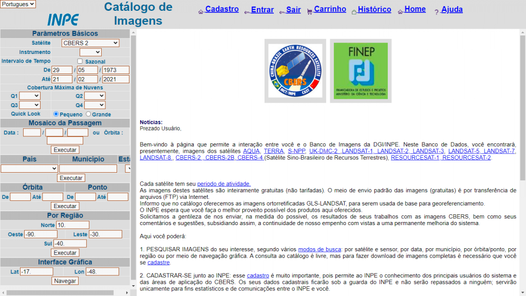
  • CBERS: The partnership between Brazil and China has their own joint mission. The key data set in this catalog is China–Brazil Earth Resources (CBERS 2). According to INPE, it will include CBERS 4, Resource Sat and UK-DMC 2 too.

The one caveat is that the data is specific to South America and Africa. If you’re OK with that, you can translate the website from Portuguese to English. Once you do that, you’ll have to create an account. Because for every request you make, INPE sends download details to your email.

Next, select your satellite and sensor. Then, choose a country in South America and Africa. Finally, add it to your cart, and click “Go Ahead”. From here, you can download your free satellite imagery from the INPE FTP site.

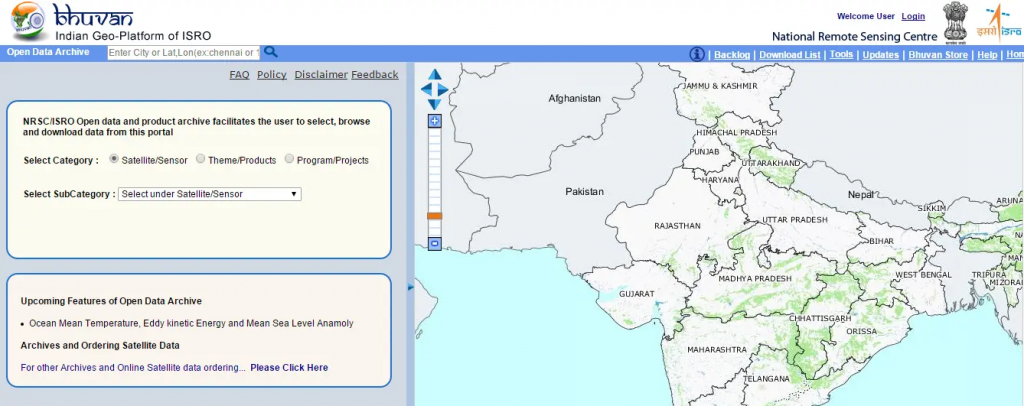
10. Bhuvan Indian Geo-Platform of ISRO

India has made tremendous strides in satellite remote sensing technology. In fact, the launch of the Indian Remote Sensing (IRS 1A) satellite dates back to 1998. Since then, data has become available on the Bhuvan Indian Geo-Platform.

The platform is well-built. But most of the data is for India only. This includes IMS-1 (Hyperspectral), Cartosat, OceanSat and ResourceSat. All are Indian satellites. The following products are also available to download outside of India:

  • NDVI: Normalized Difference Vegetation Index Global Coverage.
  • CARTODEM: This 30-meter elevation model uses stereo images from overlapping Cartosat-1 images.

11. JAXA’s Global ALOS 3D World

ALOS World 3d is a 30-meter spatial resolution digital surface model (DSM). JAXA built it and recently released it to the public. The neat thing about this is that it is the most precise global-scale elevation data at this time.

It uses the Advanced Land Observing Satellite “DAICHI” (ALOS) which is a type of L-band radar. If you want to download ALOS 3D, go to the JAXA Global ALOS portal. Next, you’ll have to register for an account. After approval, you can download it through the download portal.

12. VITO Vision

The VITO Vision website offers PROBA-V, SPOT-Vegetation and METOP as free satellite imagery. These coarse resolution satellites carve out vegetation patterns across the Earth’s surface.

It takes some time and effort to create an account for VITO Vision. The interface is intuitive and delivers free low-resolution satellite data at your fingertips. This type of data is good for big picture applications that don’t need the finer details.

13. NOAA Digital Coast

It’s all about the beautiful seashore, when you’re exploring for data on NOAA’s Digital Coast. Coastal data is all you’re going to get in this imagery platform.

To download data, select your area of interest. Define your data set to download. And sift through the results. You have benthic, elevation, imagery, land cover, and socio-economic data. You get a range of free satellite imagery to choose from such as radar, infrared, and true color composites.

14. Satellite Land Cover

We have never had this good of a perspective of our changing planet because of satellite imagery. Some of the biggest challenges we face today are best understood through satellite land cover. This is because remote sensing covers that much more ground.

  • LAND COVER: We list the best global land cover data sources from Landsat, MODIS and AVHRR. Global land cover quantifies land cover change around the world. This includes vegetation, geologic, agriculture, hydrologic and urban areas.

15. UNAVCO

Let’s cap things off with UNAVCO. University NAVSTAR Consortium (UNAVCO) is an organization of universities. If you don’t know who UNAVCO is, here’s UNAVCO Explained in 3 Minutes.

Their main goal is to support scientific research using geodesy technology. Because our world is all connected, UNAVCO provides access to geodesy data. For example, think of flooding, plate tectonics, and earthquakes.

  • SYNTHETIC APERTURE RADAR: Their platform is the UNAVCO SAR Archive Search User Interface. This website is flooded with synthetic aperture radar from satellites sources. But first, you’ll need a username and password. Then, you can finally get your hands on the data.

Summary: 15 Free Satellite Imagery Data Sources

Satellite data has opened up new channels on how we view the planet.

Instead of spending days searching for a good base map, you can tap into this list of free satellite imagery data.

You’ve learned some of the key data centers to collect free satellite imagery from around the globe.

发表评论

邮箱地址不会被公开。 必填项已用*标注