10 Sources to Download Free LiDAR Data

LIDAR, an acronym for Light Detection and Ranging, is a remote sensing method that uses light in the form of a pulsed laser to measure ranges (variable distances) to the Earth. These light pulses measure and give accurate three- dimensional imaging of the earth crust and features.
LiDAR is widely used by cartographers and GIS analyst. Data captured in LiDAR are stored in LAS format. However, the problem is the availability of LiDAR data or files in LiDAR format. The ones available cost a fortune.
This article provides information on websites to access free LiDAR data. The beauty of these websites is that they allow access to these data for FREE! Since these websites are few in number, they are difficult to find. The following are ten websites that provide these data for free.

1. LIDAR ONLINE

LIDAR-Online.com is a web platform to market LiDAR. The purpose of Lidar online is to make LiDAR data accessible to the entire geospatial community, eliminating traditional barriers as knowledge, software requirements or access to the data by making LiDAR data understandable and accessible online. The files are free, easy to use, access and download. LiDAR online has dataset spanning the globe – mostly Europe, North and South America and Africa.

2. LIDAR DATA FOR PHILIPPINES

LiDAR data on the Philippines terrain is available on LIPAD website. The LiDAR data is a flood hazard map of Philippines. The datasets, which include Digital Elevation Models (DEMs), Digital Terrain Models (DTMs), and Classified LAZ, Flood Hazard Maps and Resource Maps, are available for download in open and GIS-ready formats.

3. OPEN TOPOGRAPHY

Open Topography Facility provides online access to high-resolution topography data such as LiDAR data and other related processing tools through cyber infrastructure developed at the San Diego Supercomputer Center at University of California, San Diego. It is one of the biggest online portals to download LiDAR data.

4.GEOSUD

GEOSUD is based in France. The French website maintains the access of Free LIDAR data of few countries. These countries are from Europe, Asia, Africa and South America. To download free LiDAR data from Geosud, visit this link.

5. NATIONAL ECOLOGICAL OBSERVATORY NETWORK

National Ecological Observatory Network (NEON) provides LiDAR data on vegetation by airborne means. NEON’s airborne remote sensing flight campaigns are designed to collect quantitative information on land cover and changes to ecological structure and chemistry, including the presence and effects of invasive species across landscapes 100-300km2 surrounding NEON sites.

6. GIPUZKOA.NET (SPAIN)

The LIDAR data of the North of Spain is free which can be accessible by visiting their English version web map. Click on the grid map to download the data. Data are in LAS files of 1 sq km. the Spanish Spain government has provided free LIDAR data, you can directly download from their website Spanish government has provided free LIDAR data, you can directly download free LiDAR data from their website.

7. UNITED STATES INTERAGENCY ELEVATION INVENTORY

United States Interagency Elevation Inventory catalogs accurate elevation datasets for the United States and its territories is collaboratively maintained by six federal agencies. It has datasets files available on liDAR and IfSAR, and bathymetric data, including NOAA hydrographic surveys, multibeam data, and LiDAR. The datasets, including vertical accuracy, point spacing, and data access information.

8. USGS EARTH EXPLORER

The 
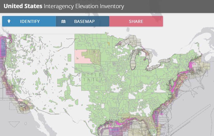
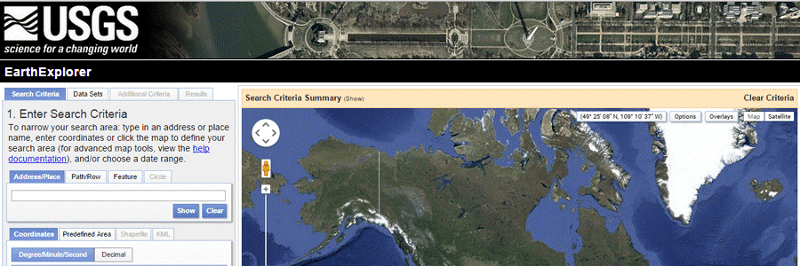
USGS EarthExplorer provides users the ability to query, search, and access satellite images, aerial photographs, and cartographic images. It has a large archive of LiDAR data. To download data, (1) Enter your search criteria (kml, coordinates, etc.). (2) In the data sets tab, select the checkbox for LiDAR. 3) Click the results tab to see what LiDAR datasets are available.

9. LIDAR DATA FOR THE UNITED KINGDOM

Centre for the Environmental Data Archival (CEDA) maintains the Free LIDAR data of the United Kingdom. CEDA hosts numerous datasets on behalf of the Natural Environment Research Council (NERC). Visit http://www.ceda.ac.uk to download free LiDAR data.

10. NATIONAL OCEANIC AND ATMOSPHERIC ADMINISTRATION

National Oceanic Atmospheric Administration (NOAA) is located in the US. It has a large collection LIDAR data set of the USA coastal regions. The data is easy to access. To download the data, go to their Data Access Viewer web map and select the area of interest using draw area tool.

发表评论

邮箱地址不会被公开。 必填项已用*标注